

West Slopes Central
Backcountry Avalanche Forecast
Author: Lee Lazzara
Issued: Friday, March 20, 2026 at 6:30 PM PDT
Expires: Saturday, March 21, 2026 at 6:30 PM PDT
The Bottom Line
 The Bottom Line
Wet, unstable snow will stick around through the weekend. Identify overhead hazards—cornices, glide cracks, cliffs, and large unsupported slopes—and avoid traveling beneath them. Expect a mountain environment that’s changed drastically, with open water, exposed hazards, and saturated or crusty snow affecting travel.
Avalanche Danger
Saturday, March 21, 2026
7500-5500ft2 - Moderate

5500-4500ft2 - Moderate
4500-2500ft2 - Moderate
Sunday, March 22, 2026
7500-5500ft2 - Moderate
5500-4500ft2 - Moderate
4500-2500ft2 - Moderate
Avalanche Danger ScaleLearn moreGeneral InfoGeneral Information1 - LowLow2 - ModModerate3 - ConsConsiderable4 - HighHigh5 - ExtrExtreme
 1 - Low | 2 - Moderate |  3 - Considerable |  4 - High |  5 - Extreme | |
|---|---|---|---|---|---|
| Travel Advice | Generally safe avalanche conditions. Watch for unstable snow on isolated terrain features. | Heightened avalanche conditions on specific terrain features. Evaluate snow and terrain carefully; identify features of concern. | Dangerous avalanche conditions. Careful snowpack evaluation, cautious route-finding and conservative decision-making essential. | Very dangerous avalanche conditions. Travel in avalanche terrain not recommended. | Extraordinarily dangerous avalanche conditions. Avoid all avalanche terrain. |
| Likelihood of Avalanches | Natural and human-triggered avalanches unlikely. | Natural avalanches unlikely; human-triggered avalanches possible. | Natural avalanches possible; human-triggered avalanches likely. | Natural avalanches likely; human-triggered avalanches very likely. | Natural and human-triggered avalanches certain. |
| Avalanche Size and Distribution | Small avalanches in isolated areas or extreme terrain. | Small avalanches in specific areas; or large avalanches in isolated areas. | Small avalanches in many areas; or large avalanches in specific areas; or very large avalanches in isolated areas. | Large avalanches in many areas; or very large avalanches in specific areas. | Very large avalanches in many areas. |
Avalanche Problems (1)
Problem #1: Glide Avalanches
Problem Type
Glide Avalanches
Aspect/Elevation
Likelihood
Size
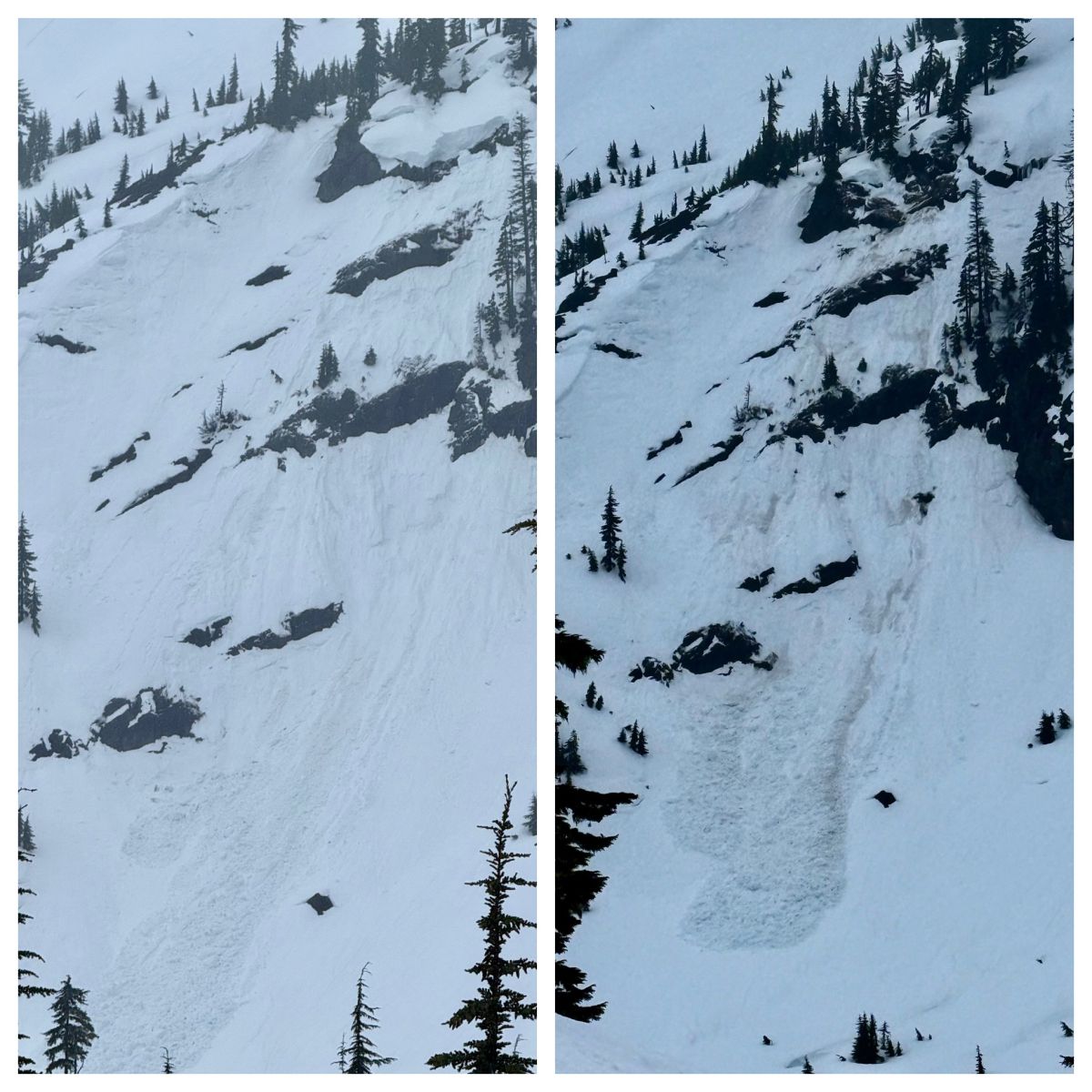
(3/18/2026)
A before and after photo of a chunk of snow breaking off a rocky perch during soggy weather. West North.
Photo: Zack McGill - Cascade Mtn Ascents
The wet, sloppy upper snowpack will start to firm up with colder temperatures overnight, but it’s a bit of a stretch to say it will be “locked up” by Saturday. Danger from glide avalanches, cornice fall, and other wet avalanche problems will keep the danger from dropping to Low.
While you might be able to push some wet snow around on steep slopes, the real danger comes from large, very unpredictable, but low-likelihood events where a large chunk of snow comes unglued from the mountain.
These aren’t the kind of problems for which you can evaluate stability. It’s also unlikely that you would trigger one. The only real risk mitigation strategy is to limit exposure to terrain below cornices, snowy cliffs, glide cracks, wrinkled-looking snow, and anything else that looks sketchy and poorly attached to the mountain.
Forecast Discussion
If you get into alpine terrain, you might find dry snow and storm or wind slab avalanche problems. Evaluate stability before heading into steep terrain. Strong sun could help initiate wet avalanches in the uppermost layer of new snow.
It’s worth totaling precipitation amounts and other stats now that the rainfall is more or less over. The numbers in some locations are eye-popping. The Skookum Ridge SNOTEL picked up over 13” of precipitation since Monday, with most other stations showing between 5 and 8 inches over the same period.
As usual, these totals drop as you head east, with only 4.1” at Lyman Lake (which sits near the spine of the Cascade Range). Snowpack depths lost significant ground, with nearly all stations showing a 20–25% reduction in total snow depth since seasonal highs last weekend. Temperatures hovered in the upper 30s and low 40s throughout the week, even at upper-elevation stations like Lyman (5,990 feet).
Numerous wet avalanches were reported in lower-elevation terrain at Snoqualmie Pass, and an NWAC forecaster in Stevens Pass observed a handful of large avalanches despite poor visibility. No observations were submitted from West Central, but it’s reasonable to assume there has been similar activity given the size of the zone, the steepness of the terrain, and the amount of rain that fell on a dry upper snowpack.
This information is provided by the U.S.D.A. Forest Service and describes general backcountry avalanche hazard and conditions.
It does not apply to ski areas and highways where avalanche mitigation is conducted.