

West Slopes North
Backcountry Avalanche Forecast
Author: Irene Henninger
Issued: Saturday, February 28, 2026 at 6:41 PM PST
Expires: Sunday, March 1, 2026 at 6:00 PM PST
The Bottom Line
 The Bottom Line
Although chances are slim, a deep, very large, and unsurvivable avalanche could happen naturally or with a human trigger, similar to what occurred in the Baker backcountry Saturday afternoon. Especially as temperatures warm, avoid traveling beneath large, smooth slopes. South-facing crusts will quickly soften and become moist, and if rollerballs or small loose avalanches begin occurring, shift travel to cooler, shadier slopes.
Avalanche Danger
Sunday, March 1, 2026
7500-5500ft3 - Considerable

5500-4500ft3 - Considerable
4500-2500ft2 - Moderate

Monday, March 2, 2026
7500-5500ft3 - Considerable
5500-4500ft3 - Considerable
4500-2500ft2 - Moderate
Avalanche Danger ScaleLearn moreGeneral InfoGeneral Information1 - LowLow2 - ModModerate3 - ConsConsiderable4 - HighHigh5 - ExtrExtreme
 1 - Low | 2 - Moderate | 3 - Considerable |  4 - High |  5 - Extreme | |
|---|---|---|---|---|---|
| Travel Advice | Generally safe avalanche conditions. Watch for unstable snow on isolated terrain features. | Heightened avalanche conditions on specific terrain features. Evaluate snow and terrain carefully; identify features of concern. | Dangerous avalanche conditions. Careful snowpack evaluation, cautious route-finding and conservative decision-making essential. | Very dangerous avalanche conditions. Travel in avalanche terrain not recommended. | Extraordinarily dangerous avalanche conditions. Avoid all avalanche terrain. |
| Likelihood of Avalanches | Natural and human-triggered avalanches unlikely. | Natural avalanches unlikely; human-triggered avalanches possible. | Natural avalanches possible; human-triggered avalanches likely. | Natural avalanches likely; human-triggered avalanches very likely. | Natural and human-triggered avalanches certain. |
| Avalanche Size and Distribution | Small avalanches in isolated areas or extreme terrain. | Small avalanches in specific areas; or large avalanches in isolated areas. | Small avalanches in many areas; or large avalanches in specific areas; or very large avalanches in isolated areas. | Large avalanches in many areas; or very large avalanches in specific areas. | Very large avalanches in many areas. |
Avalanche Problems (2)
Problem #1: Deep Persistent Slab
Problem Type
Deep Persistent Slab
Aspect/Elevation
Likelihood
Size
(2/28/2026)
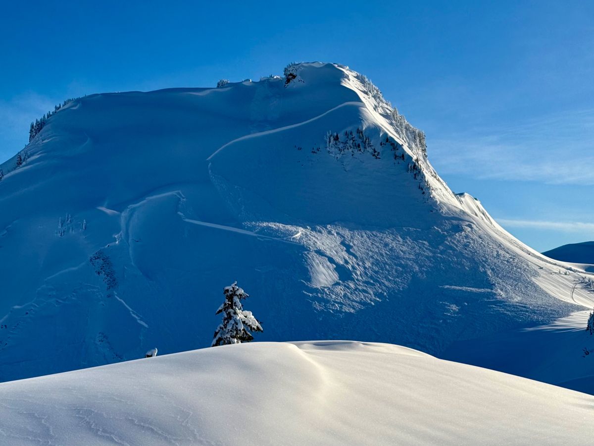
A very large natural avalanche that occurred in Video Peak in the Baker backcountry at 4:19pm on 2/28. This is the only one we've seen like this, but it's hard to ignore. 5500ft, N-NW, HS-N-D3-U
Photo: Zack McGill - Cascade Mtn Ascents
A very large natural avalanche (observation) occurred in the Baker backcountry late afternoon Saturday. This may be the only one like it, but we really aren't sure, and it's too scary to ignore. These may increase in likelihood as temperatures increase into Sunday, and wetting occurs on slopes facing the sun, impacting shallower buried weaknesses that may continue to propagate into thicker areas.
Identify overhead hazards where you travel. Although the likelihood is low, you may want to consider steering clear of large, smooth, steep slopes and areas beneath them at upper and mid elevations, especially as the day warms. We don't expect large or very large avalanches at lower elevations, but larger avalanches may run down to these areas.
Problem #2: Wet Loose
Problem Type
Wet Loose
Aspect/Elevation
Likelihood
Size
(2/28/2026)
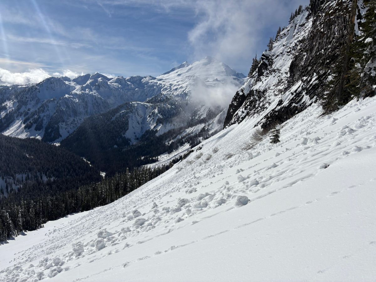
Rollerballs on steep, sunny slopes midday Saturday. Expect more, possibly turning into wet loose avalanches on Sunday.
Photo: Julz Holder - Grounding Truth
Wet loose avalanches will be possible when crusts from Saturday break down and snow gets wet. Avalanche size will vary with how much recent snow has accumulated—expect larger, more consequential slides in areas that picked up the most new snow. Size also depends on terrain, as steep, sustained fall-line slopes can produce more powerful avalanches. But even a small wet loose avalanche can pose a serious risk if it carries you over a cliff, into a creek, or through rocks or trees. Keep track of sunny slopes overhead as the day warms.
Forecast Discussion
Several small to large natural avalanches occurred in recent storm layers, mainly as natural avalanches early Friday morning. A few more occurred on Saturday. Folks were out in full force, both sledding and traveling under human power, and only a few human-triggered avalanches were reported. Some avalanches were small and isolated. You may still trigger slab avalanches in newer snow layers on Sunday, epsecially in wind loaded areas. Cornices could start failing, triggering slab avalanches on underlying slopes with the warm temperatures we're seeing on Sunday as well.
In the West North zone, avalanche activity has been limited and sporadic. Red flags like whumphing and shooting cracks have not been widespread, and persistent weak layers have been harder to find—though not impossible. This one large natural avalanche could be an indicator of more to come as temperatures warm up.
Avalanche forecasts for large zones are often difficult to pin to a single danger rating, and Sunday may be especially challenging given the wide variation in new snow amounts, the potential for both slab and loose avalanches, and the uncertain distribution of persistent weak layers. Be prepared to find danger higher or lower depending on where you travel within the zone. Build flexibility into your plan so you can adjust based on what you find. With new evidence of very occasional large natural slab avalanches, this makes it even more tricky- you probably won't find signs of instability, but there's the tiny chance a very large avalanche could occur unexpectedly.
This information is provided by the U.S.D.A. Forest Service and describes general backcountry avalanche hazard and conditions.
It does not apply to ski areas and highways where avalanche mitigation is conducted.