

West Slopes North
Backcountry Avalanche Forecast
Author: Lee Lazzara
Issued: Thursday, March 5, 2026 at 6:00 PM PST
Expires: Friday, March 6, 2026 at 6:00 PM PST
The Bottom Line
 The Bottom Line
Expect a mix of wet and dry avalanche problems depending on elevation. Wet snow avalanches are a concern at low and mid elevations below cliffs and other very steep slopes. New snow at upper elevations should form small slabs, especially on wind-loaded slopes.
Avalanche Danger
Friday, March 6, 2026
7500-5500ft2 - Moderate

5500-4500ft2 - Moderate
4500-2500ft1 - Low

Saturday, March 7, 2026
7500-5500ft3 - Considerable

5500-4500ft2 - Moderate
4500-2500ft1 - Low
Avalanche Danger ScaleLearn moreGeneral InfoGeneral Information1 - LowLow2 - ModModerate3 - ConsConsiderable4 - HighHigh5 - ExtrExtreme
1 - Low | 2 - Moderate | 3 - Considerable |  4 - High |  5 - Extreme | |
|---|---|---|---|---|---|
| Travel Advice | Generally safe avalanche conditions. Watch for unstable snow on isolated terrain features. | Heightened avalanche conditions on specific terrain features. Evaluate snow and terrain carefully; identify features of concern. | Dangerous avalanche conditions. Careful snowpack evaluation, cautious route-finding and conservative decision-making essential. | Very dangerous avalanche conditions. Travel in avalanche terrain not recommended. | Extraordinarily dangerous avalanche conditions. Avoid all avalanche terrain. |
| Likelihood of Avalanches | Natural and human-triggered avalanches unlikely. | Natural avalanches unlikely; human-triggered avalanches possible. | Natural avalanches possible; human-triggered avalanches likely. | Natural avalanches likely; human-triggered avalanches very likely. | Natural and human-triggered avalanches certain. |
| Avalanche Size and Distribution | Small avalanches in isolated areas or extreme terrain. | Small avalanches in specific areas; or large avalanches in isolated areas. | Small avalanches in many areas; or large avalanches in specific areas; or very large avalanches in isolated areas. | Large avalanches in many areas; or very large avalanches in specific areas. | Very large avalanches in many areas. |
Avalanche Problems (3)
Problem #1: Wet Loose
Problem Type
Wet Loose
Aspect/Elevation
Likelihood
Size
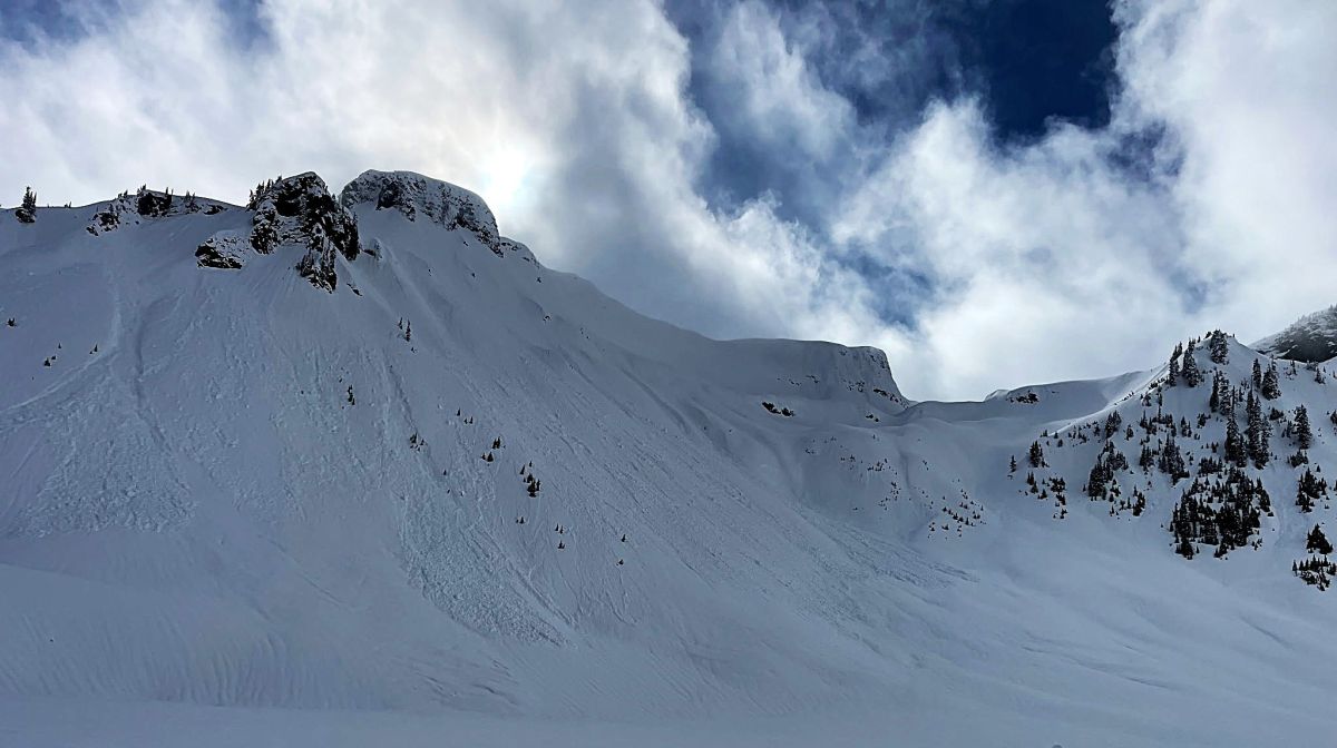
Recent wet avalanches on the north side of Table Mt that initiated at 5000. They likely released during rainfall a few days ago.
Photo: Jan Osobov - Cascade Mountain AscentsThe number and size of wet-loose avalanches on Friday are up for debate, but it is a given the upper snowpack is currently moist or wet up to 5000-5500 feet. It should mostly stay that way with rising snow levels and light rainfall.
Avoid travel on or directly below slopes showing signs of wet avalanche instability, such as rollerballs and very small wet slides, or where the snow is wet and sloppy. If rainfall is greater than expected, we could start to see wet slab avalanche activity as well.
Problem #2: Storm Slab
Problem Type
Storm Slab
Aspect/Elevation
Likelihood
Size
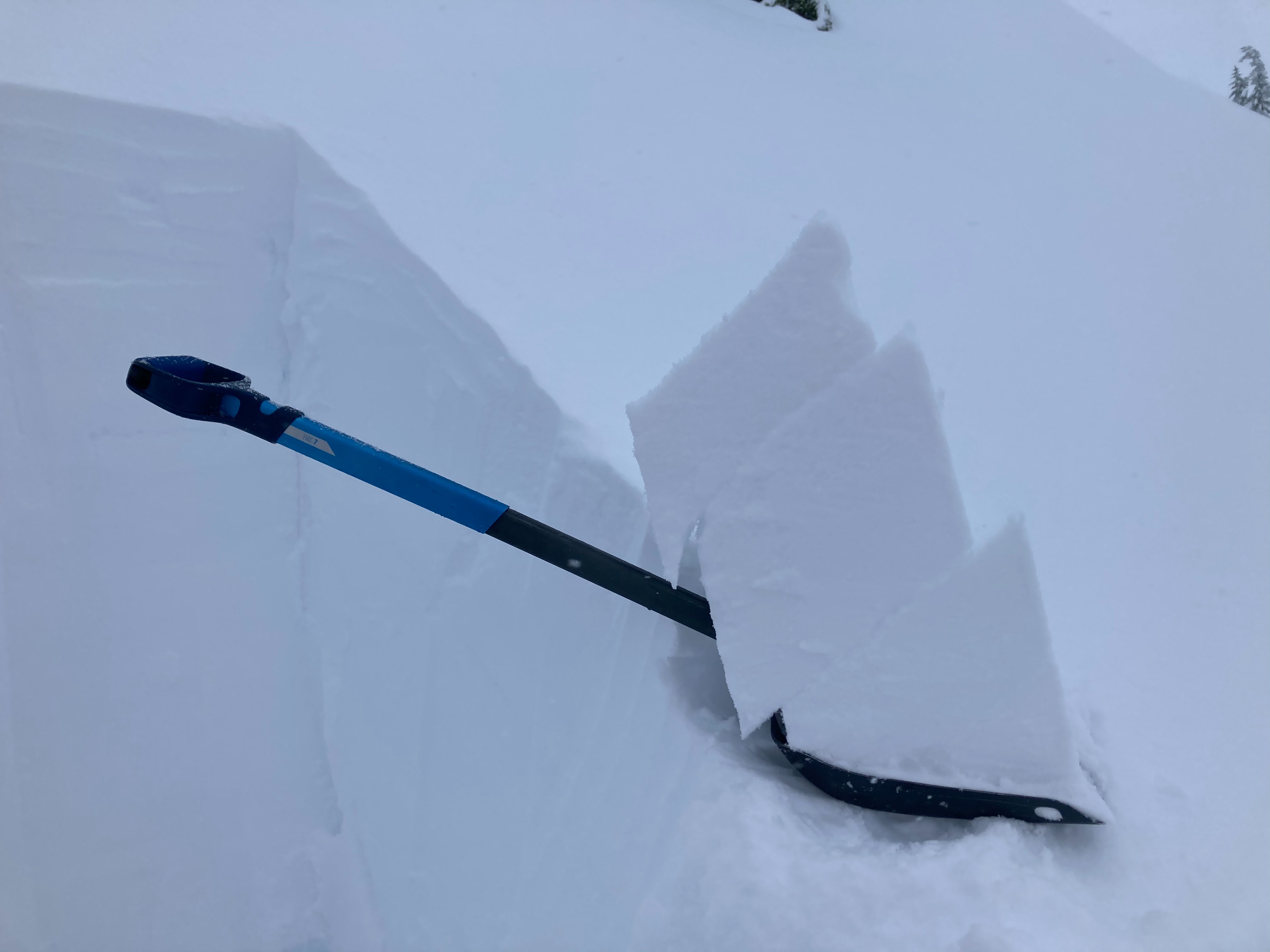
(12/18/2020)
Storm slab avalanches can fail at the old-new snow interface or within the layers of new snow.
New snow amounts are not impressive, but the warming trend at higher elevations could create shallow new-snow instabilities. Look for strong-over-weak layering as you gain elevation, and use hand pits and test slopes to evaluate the bond of new snow layers.
Winds are not forecast to be particularly strong, but you are still more likely to trigger an avalanche on wind-loaded slopes that hold slightly thicker and more sensitive slabs. Unstable slabs might also be found at and below 5000 feet in the morning if colder, drier snow falls overnight.
Problem #3: Persistent Slab
Problem Type
Persistent Slab
Aspect/Elevation
Likelihood
Size
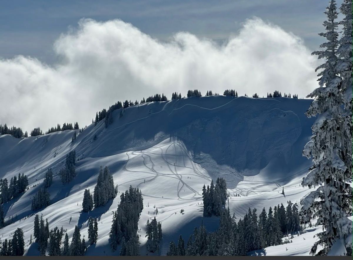
(3/1/2026)
A large, snowmobile-triggered avalanche in Canyon Creek. This likely occurred on a persistent layer, based on the wide propagation and nearby snowpit data.
The persistent slab avalanche problem is trending less likely. The mountains have seen continued loading from rain and wet snow, but no new slab avalanches have been reported in areas that saw the most persistent slab activity over the weekend. Numerous wet-loose avalanches in the past day or two have also not pulled out any large slabs. That said, this problem remains on the radar in select locations, such as Excelsior Ridge in Canyon Creek, in or near North Cascades National Park, or along the Canadian border.
It’s possible to dig down and look for layers of buried surface hoar or facets and evaluate stability. Whumphing or shooting cracks are red flags, but don't count on getting warned beforehand. The easiest solution might be to avoid steep, unsupported slopes in areas where these avalanches were reported over the weekend. These layers could also wake up with a bigger shot of rain this weekend.
Forecast Discussion
The main avalanche problem transitioned from drier slabs to wet avalanches through the day in the Baker Backcountry. Avalanche control work first thing Thursday morning produced very easy-to-trigger but shallow, small slabs on most aspects above 4500 feet. Warming and wet snow took hold as temperatures climbed significantly higher than forecasted, and thin clouds allowed for greenhouse conditions. Small natural wet avalanches were observed in the afternoon, and it was reported to be quite easy to get wet snow moving on very steep slopes. Debris from larger, slightly older wet avalanches was visible around Upper Bagley.
The mountains have picked up anywhere from 4 to 10 inches of new snow, with areas farther west in the zone favored for more precipitation under the current wind direction. Deeper weak layers that produced large and dangerous avalanches in other parts of West North are now buried four or more feet deep in the Baker Backcountry and have not produced significant results in testing. The upper snowpack at low and mid elevations is moist due to recent rainfall and continued warm temperatures.
This information is provided by the U.S.D.A. Forest Service and describes general backcountry avalanche hazard and conditions.
It does not apply to ski areas and highways where avalanche mitigation is conducted.