

West Slopes North
Backcountry Avalanche Forecast
Author: Lee Lazzara
Issued: Friday, March 6, 2026 at 6:00 PM PST
Expires: Saturday, March 7, 2026 at 6:00 PM PST
The Bottom Line
 The Bottom Line
Avoid travel on or directly under steep slopes where you see fresh rollerballs, small wet avalanches, or where the snow is wet and sloppy. Wet avalanches and cornice fall can also trigger a much larger avalanche on the slopes below. Expect greater danger if rainfall is heavier than forecast or lasts longer into Saturday morning.
Avalanche Danger
Saturday, March 7, 2026
7500-5500ft2 - Moderate

5500-4500ft2 - Moderate
4500-2500ft1 - Low

Sunday, March 8, 2026
7500-5500ft3 - Considerable

5500-4500ft2 - Moderate
4500-2500ft1 - Low
Avalanche Danger ScaleLearn moreGeneral InfoGeneral Information1 - LowLow2 - ModModerate3 - ConsConsiderable4 - HighHigh5 - ExtrExtreme
1 - Low | 2 - Moderate | 3 - Considerable |  4 - High |  5 - Extreme | |
|---|---|---|---|---|---|
| Travel Advice | Generally safe avalanche conditions. Watch for unstable snow on isolated terrain features. | Heightened avalanche conditions on specific terrain features. Evaluate snow and terrain carefully; identify features of concern. | Dangerous avalanche conditions. Careful snowpack evaluation, cautious route-finding and conservative decision-making essential. | Very dangerous avalanche conditions. Travel in avalanche terrain not recommended. | Extraordinarily dangerous avalanche conditions. Avoid all avalanche terrain. |
| Likelihood of Avalanches | Natural and human-triggered avalanches unlikely. | Natural avalanches unlikely; human-triggered avalanches possible. | Natural avalanches possible; human-triggered avalanches likely. | Natural avalanches likely; human-triggered avalanches very likely. | Natural and human-triggered avalanches certain. |
| Avalanche Size and Distribution | Small avalanches in isolated areas or extreme terrain. | Small avalanches in specific areas; or large avalanches in isolated areas. | Small avalanches in many areas; or large avalanches in specific areas; or very large avalanches in isolated areas. | Large avalanches in many areas; or very large avalanches in specific areas. | Very large avalanches in many areas. |
Avalanche Problems (2)
Problem #1: Wet Loose
Problem Type
Wet Loose
Aspect/Elevation
Likelihood
Size
(4/5/2021)
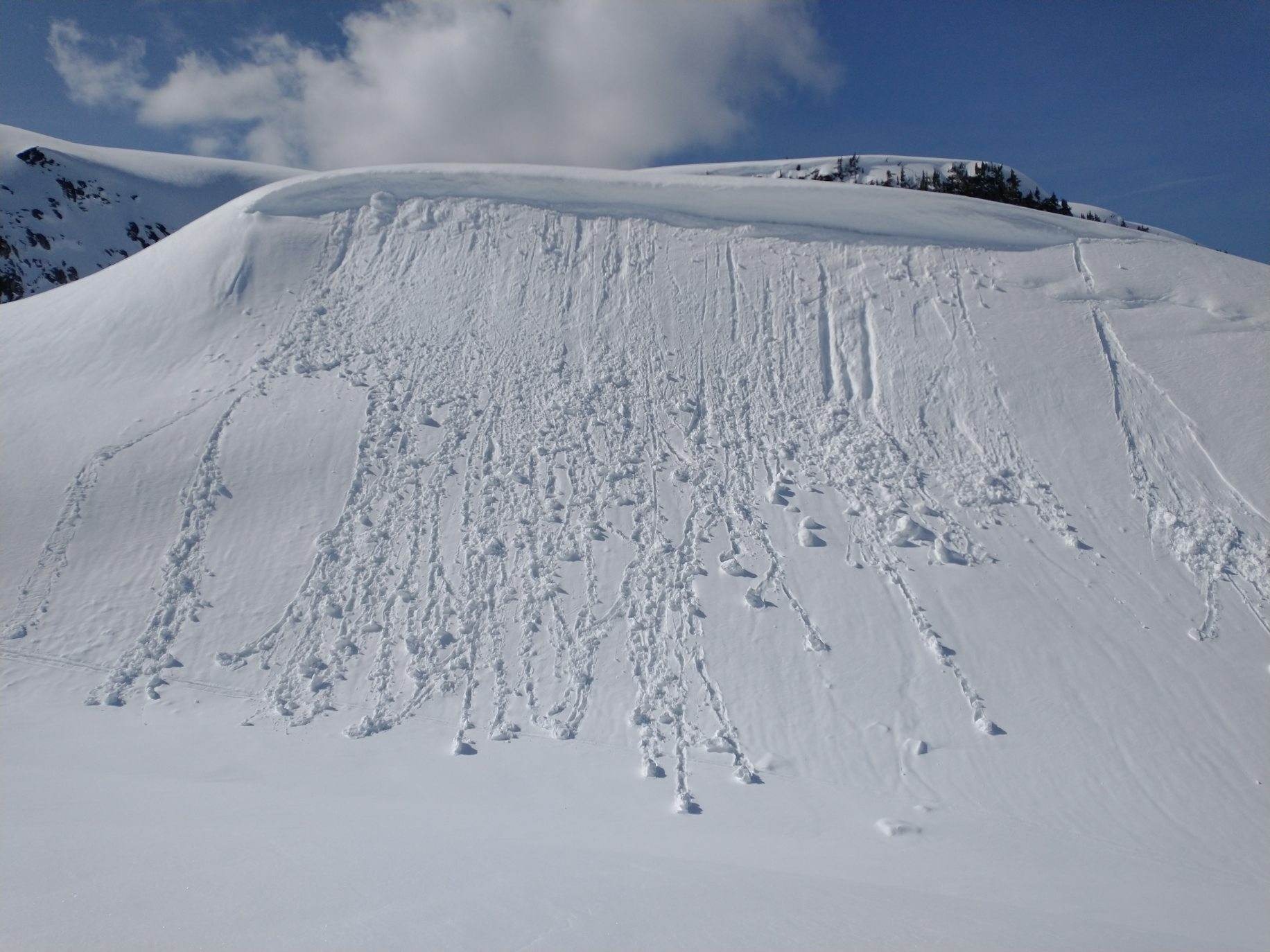
Rollerballs released beneath this small cornice as slopes warmed. This is oftentimes a precursor to wet loose avalanches.
Photo: Andy Harrington
Warm temperatures, high snow levels, and light rain will keep wet avalanches on the radar Saturday. Most rainfall should occur overnight, but drizzle and mild temperatures may continue to add moisture to the upper snowpack through the day. The already-moist and dense top foot of snowpack may handle some rain. However, softer and drier layers can still be found above about 5000 feet and may become reactive with additional rain or warming.
Cornice fall is also a concern. Large ridgeline cornices could weaken with rain and warm temperatures, potentially triggering avalanches on the slopes below. Shallow wet slab avalanches are also possible at upper elevations. Keep track of terrain above you and be ready to limit your exposure if conditions become more active than expected.
Problem #2: Persistent Slab
Problem Type
Persistent Slab
Aspect/Elevation
Likelihood
Size
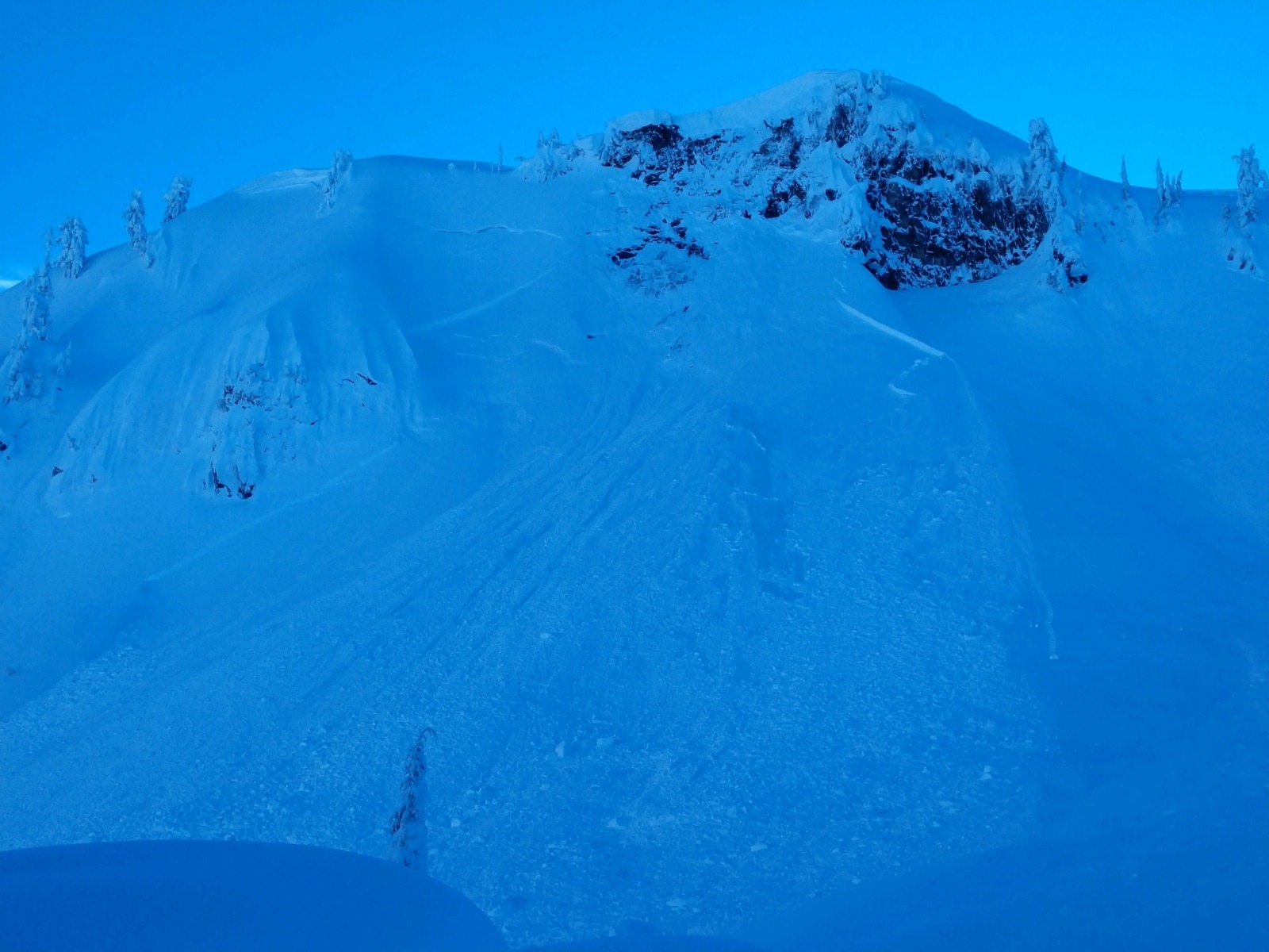
Example of a slab triggered by a cornice shedding off the ridgeline above.
The likelihood of a person triggering a persistent slab avalanche is very low considering the amount of precipitation over the past four days, the time and warm temperatures that allow weak layers to settle, bond, and gain strength, and the isolated distribution of the problem.
The concern is that cornice fall or a smaller natural wet avalanche could provide the larger trigger needed to release a persistent slab. Give large cornices a wide berth—definitely don’t have lunch in the rain under one. Also, avoid traveling below steep slopes where you observe fresh wet avalanches or other signs of instability.
Forecast Discussion
If weather conditions play out as forecast, avalanche danger could effectively be Low, with most wet avalanche activity occurring overnight. However, the day could feel quite Considerable if a falling cornice triggers a slab on the slope above you. Fortunately, an event like this is very unlikely and generally easy to anticipate by evaluating the terrain ahead.
Backcountry observers reported that yesterday’s wet snow surfaces firmed up enough overnight to form a breakable crust below about 5000 feet. A few inches of soft snow topped the crust, but it didn’t do much to improve riding conditions. The crust became softer with elevation gain, eventually forming a stiff slab of moist snow over softer, drier layers below. This very shallow slab produced localized cracking and small reactive pockets on test slopes. Temperatures warmed slightly through the day, but only a few rollerballs were reported.
This information is provided by the U.S.D.A. Forest Service and describes general backcountry avalanche hazard and conditions.
It does not apply to ski areas and highways where avalanche mitigation is conducted.