

West Slopes North
Backcountry Avalanche Forecast
Author: Irene Henninger
Issued: Wednesday, March 11, 2026 at 6:30 PM PDT
Expires: Thursday, March 12, 2026 at 6:30 PM PDT
The Bottom Line
 The Bottom Line
Conditions will be very dangerous on Thursday, with larger and more reactive slides happening at higher elevations. Avoid all steep slopes, and if there are significant red flags like whumphing or natural avalanches, then avoid all avalanche terrain, including beneath large avalanches where a slide would stop. When in doubt, avoid all avalanche terrain.
Avalanche Danger
Thursday, March 12, 2026
7500-5500ft4 - High

5500-4500ft3 - Considerable

4500-2500ft3 - Considerable
Friday, March 13, 2026
7500-5500ft3 - Considerable
5500-4500ft3 - Considerable
4500-2500ft2 - Moderate

Avalanche Danger ScaleLearn moreGeneral InfoGeneral Information1 - LowLow2 - ModModerate3 - ConsConsiderable4 - HighHigh5 - ExtrExtreme
 1 - Low | 2 - Moderate | 3 - Considerable | 4 - High |  5 - Extreme | |
|---|---|---|---|---|---|
| Travel Advice | Generally safe avalanche conditions. Watch for unstable snow on isolated terrain features. | Heightened avalanche conditions on specific terrain features. Evaluate snow and terrain carefully; identify features of concern. | Dangerous avalanche conditions. Careful snowpack evaluation, cautious route-finding and conservative decision-making essential. | Very dangerous avalanche conditions. Travel in avalanche terrain not recommended. | Extraordinarily dangerous avalanche conditions. Avoid all avalanche terrain. |
| Likelihood of Avalanches | Natural and human-triggered avalanches unlikely. | Natural avalanches unlikely; human-triggered avalanches possible. | Natural avalanches possible; human-triggered avalanches likely. | Natural avalanches likely; human-triggered avalanches very likely. | Natural and human-triggered avalanches certain. |
| Avalanche Size and Distribution | Small avalanches in isolated areas or extreme terrain. | Small avalanches in specific areas; or large avalanches in isolated areas. | Small avalanches in many areas; or large avalanches in specific areas; or very large avalanches in isolated areas. | Large avalanches in many areas; or very large avalanches in specific areas. | Very large avalanches in many areas. |
Avalanche Problems (1)
Problem #1: Storm Slab
Problem Type
Storm Slab
Aspect/Elevation
Likelihood
Size
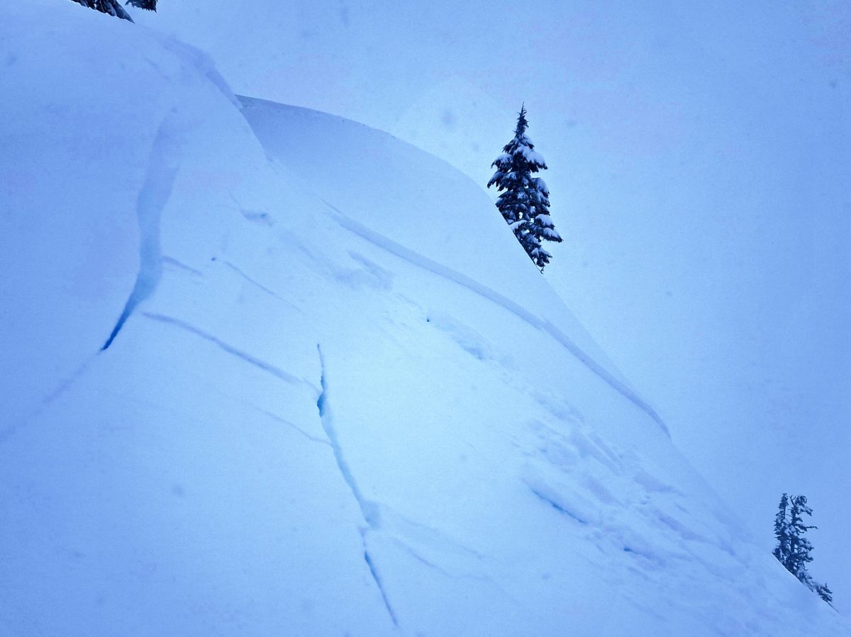
(3/11/2026)
Crown of a large slab triggered from the ridge just above in the Baker backcountry. Slope was actively getting loaded with wind-drifted snow.
(SS-D2-ASr-I)
Photo: Lee Lazzara
Peak avalanche activity likely occurrs Wednesday night during the most intense precipitation, but this isn't your usual PNW snowpack, where slopes will stabilize in a few hours. Expect avalanches to be more reactive than expected, and spread wider than you're used to on Thursday. Human-triggered avalanches could be very likely, and natural avalanches are possible.
Avoid all steep slopes, and if you make your way towards the alpine, or see evidence of recent natural avalanches or experience whumphing, stay away from areas beneath avalanche paths as well. This isn't a day to push your luck.
Forecast Discussion
This isn't your average PNW snow storm - a layer of almost two feet of light, fluffy snow sits under heavier and more wind-affected snow from late Wednesday. Cooling temperatures, more gale force winds, and another foot of snow overnight will result in plenty of natural avalanches. By Thursday, wind will back off to a mere moderate breeze, and another six inches of snow should fall. We don't expect snow to stabilize as quickly as it commonly does, since it will likely take longer for the thick layer of low-density snow to adjust.
Forecasters and observers in the Baker backcountry on Wednesday found quickly decreasing stability Wednesday afternoon. Large soft slab avalanches were easily triggered, although natural avalanches weren't reported yet. Many of these failures were in a mid-storm layer. The avlaanches they did trigger were surprising in being wider and larger than expected.
This storm produced over two inches of water since March 8 by forecast time on Wednesday in most areas of the zone, which could translate to 2 or more feet of snow capped by a heavier layer. Drifts could be enormous, and this almost feels like the start of winter now that it's March.
This information is provided by the U.S.D.A. Forest Service and describes general backcountry avalanche hazard and conditions.
It does not apply to ski areas and highways where avalanche mitigation is conducted.